Since Google Maps launched in 2005, it has been the go-to app for getting around. According to a stat, Google Maps facilitates over 20 billion kilometers of directions each day.
While undoubtedly a remarkable innovation, even the most exceptional tools can encounter occasional hiccups. At times, you might have found Google Maps showing confusing routes.
However, with the new updates, those problems will be fixed once and for all.
In December 2023, Google’s latest update brought the power of AI to Google Maps, making it an even more indispensable tool for our daily lives.
List of Google Maps’s AI-Powered Features
Let’s examine these new abilities and how they will help you reach your destination!
1. Immersive View for Routes
This groundbreaking functionality builds upon Google’s existing efforts with Immersive View for Places, where AI seamlessly blends Street View and aerial imagery to provide immersive previews of destinations.
It has the ability to generate routes in a 3D format, which provides a lifelike depiction of the journey you will be taking, whether by car, on foot, or by bike.
You can get detailed visual turn-by-turn directions to anticipate each bend and intersection as if you were physically present. What’s more, with its time slider, Google Maps can simulate real-time traffic and weather conditions, allowing you to strategize departure.
A very handy feature for navigating through unfamiliar or complex areas.
Here is an example:
If you are planning a scenic bike ride along the waterfront to San Francisco’s Palace of Fine Arts, simply request cycling directions on Google Maps, then tap into the Immersive View preview.
Instantly, your screen will display a stunning, multidimensional representation of your route.

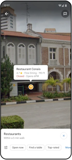
2. Lens in Maps
Google Maps now combines the power of AI and augmented reality technology that enables you to interact with your surroundings in real time. With this, Google Maps can identify and label objects and places instantaneously through your device’s camera view.
Suppose you are upon reaching a destination, you want to find a place to orient yourself or find nearby points of interest. All you have to do is tap on the Lens icon in the search bar, lift, and move your phone across the streets; you will be able to see a wealth of insights about nearby ATMs, transit stations, restaurants, and coffee shops on your screen.
This streamlined approach to discovery enables you to navigate with confidence and discover local treasures with ease.
3. Detailed Maps
In the newer version, Google has made a lot of efforts to reflect the real world in their maps with higher levels of accuracy, which means you will be able to see more realistic representations of buildings, which will aid you in orienting while driving.
On top of that, Google has improved its lane details on highways, which allows you to be well-prepared for turns.
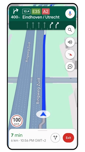
Google Maps is also empowering you with greater decision-making capabilities by introducing visibility into High Occupancy Vehicle (HOV) lanes along their routes, which invaluable information enables you to take the most efficient route to reach your destination.
In some countries, Google is testing its AI-powered speed limit information feature, which equips you with real-time speed limit updates based on the highway you are on.
The thought behind this is to improve road safety even in areas where speed limit signs may be scarce or aren’t easy to spot.
4. EV Information
If you are an owner of an Electric Vehicle (EV), you must have dealt with charging anxiety. Finding a charging station mid-journey can ruin your driving experience.
To address this issue, Google Maps has added a series of features tailored specifically for EV drivers.
Google Maps now offers comprehensive charging station information for EV drivers on both Android and iOS platforms that includes crucial details such as charger compatibility with the user’s vehicle and the charging speed—whether fast, medium, or slow—enabling drivers to find a charging station that can fulfill the specific needs of their EV.
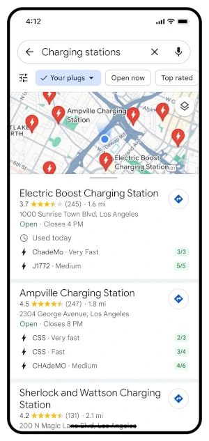
Recognizing the prevalence of non-functional chargers, Google Maps goes a step further by providing insights into the usage status of charging stations.
Side Note: If you are a developer, this news will interest you. Google Maps is democratizing access to EV charging information by making it available to developers through its Places API. EV companies can easily incorporate real-time charging station data into their websites and apps.
5. New Ways to Search
Are you looking for a specific experience but don’t know where to go?
Well, Google Maps has upgraded its search functionality to help you find things to do quickly and visually.
Let’s understand with an example.
Suppose one lazy summer afternoon, and you want to look at animal latte art. Just type “animal latte art” in the Google Maps search box, and you’ll see photo-first results for your search.

You can easily scroll through these results. Tap the photo to learn more about the place and get the directions.
Google Maps is able to recommend these images based on the analysis of billions of community-shared photos. Advanced image recognition models combined with AI are used to improve the accuracy of this analysis.
Here are scenarios where Google Maps can help you search places:
There are moments in our lives when we want to go outside and enjoy but aren’t quite sure where to start.
For that, Google Maps now has the ability to generate better-organized results, which works similarly to how you get results for a typical Google search.
For example, if you are on leave and it’s raining outside, but you are in the mood for a fun activity, you can type “activities for a rainy day” in the Google Maps search box. It will then suggest a plethora of indoor activities that you can enjoy.

You can save the suggestion you like or explore other related options.
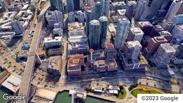
6. New Ariel View API
The new Ariel View API in Google Maps offers enhanced satellite imagery for a bird’s eye view of locations, which provides detailed aerial perspectives, aiding in better navigation and exploration.
Users can now visualize landscapes, buildings, and terrain with stunning clarity, making it easier to identify landmarks and plan routes effectively.
The Ariel View API enhances the mapping experience by delivering high-resolution images, improving overall map accuracy, and offering a more immersive way to discover and interact with locations on Google Maps.
Conclusion
These were the latest upgrades done on Google Maps.
The introduction of AI, along with other cutting-edge technology in Google Maps, is a significant leap forward. It will make navigating more intuitive, informative, and accessible.
In fact, we can say that Google has not only redefined navigation but also reimagined the way we discover and engage with the world.
So, the next time you open Google Maps, be prepared to be amazed!